unassumingly difficult mt kawanori : August 10 2024
our mountain hike has finally come into fruition, it was postponed for weeks now.
rain proved to be a difficult opponent, but the time has finally come.
with a different mountain to climb, the weather finally cooperated.
mt kawanori
it was an early morning ride, a bit early for comfort on my end.
specially after that late night fun filled friday, waking early is a bit hard.
but i did!
by 8:45, we arrived at the trecking entrance.
all people in our bus were headed here as well.
a crowd formed by the entrance, and they all vanished slowly as they started trecking.
we were one of the last ones to leave.
i honestly thought we could surpass two or three groups of hikers along the way.
none of that happened.
it seemed like they vanished into thin air.
we eventually reached the rugged terrains, that paved walkway took forever.
we found ourselves meandering along the river.
bridges were the most basic i have seen among all the other hiking spots i have been on.
it is but wood planked on the two edges of a cliff.
we finally reached a mini waterfall, one of the difficult trails to traverse.
oh yes, we caught up one hiking group and they had a hard time getting up this area.
we had a first hand view of how to do it, we had enough experience.
we passed by slightly faster, so proud of that achievement.
wooden bridges were everywhere.
and given that it rained the other day, some of them were still wet.
slippery.
moldy slippery.
ordinary sneakers or running shoes will not work.
we were now heading upwards, we had to say our last goodbyes to the rivers below.
we have walked past the hiking group again, and have lost them till the end.
i still have no idea where they went down.
the terrain is starting to get rocky.
of all the hiking terrains, i enjoy rocks when going up.
rocks gives me security, the bigger the better.
i enjoy the big steps, using leg muscles when trying to sprung yourself upwards.
this rocky terrain went on for a couple more kilometers.
we were over the river, but that doesn’t mean that there were no other bodies of water up the trails.
we reached this sort of dried off valley, i immediately thought that this must be where melted snow and ice flows down from the mountain top.
some waters were still there.
this is the last view of water.
the trail to the peak was a very hectic one, it was nothing but a continuous uphill climb.
i climbed with @ohlnwwlknat, @thinkeringbart and another friend; we were all exhausted at this point.
and the trail was something easy to get lost in, we were so thankful of our cellphone app for climbing.
we would have been lost if not for the app.
by this point we saw 4 other hikers; we were all heading for the same goal, to reach the peak.
we decided to eat lunch at a clearing before reaching the peak.
three of us headed on to the peak, another one stayed and decided to rest some more; we will be going back to the same clearing after all.
that marker was everything there was at the peak, no signs of civilization in site.
if in other peaks, stores and even vending machines could be seen, there was none of those in here.
that marker was all i came for anyway, this mountain was as virgin and as untouched as can be.
we saw a group of 4 hikers eating their lunch; that group of 4 would became the reciprocate of our "konnichiwa"s downhill.
this mountain had the fewest hikers so far, probably because it was in the middle of summer.
most hikers had the brains not to hike in this very hot season, i guess.
we on the other hand just want to experience how it really was, this coming monday was a national holiday dedicated to the mountains after all.
isn’t that a sign that mountains are meant to be climbed on summer?
at least these insects believed that climbing in summer is a good call.
the downhill trail was one of the most difficult so far.
i always love downhill trails, i still did halfway down the mountain.
it was a series of downward stairs of wood and rocks, and long flat walks along mountain sides.
there was one time where we had to climb over a big log which blocked the trail.
i decided to climb up and jump down, that was a very bad decision; this still haunts me now while i am writing this entry.
after that point, i felt some strain on my left lateral knee.
and this prevented me from enjoying the best out of the whole experience.
every time i step down, i felt some pain on my left knee.
i just thought of getting down as fast as i can without giving more strain to that knee, i just wanted to sit long on a bench and stretch my legs.
i was getting low on liquids as well, we all were.
this is the worst when climbing on summer.
i under estimated my water intake, i conserved as much water as i can while trying to step carefully on my left leg.
i had to think not to go so fast, although i was now admittedly slower than my usual.
but i also wanted to get down as fast to get that much needed water.
i had so much on mind but the end goal was nowhere in sight.
we finally reached civilization, the mountain trail was over.
my knees were in so much pain now, my left leg muscles were killing me.
each step i took was painful, but i kept smiling though, i just don’t want to bother my fellow hikers.
we were all in bad shape.
i struggled to walk even on the paved roads, but i know this is the last of the trail, just a few more steps and it will be over.
i watched my fellow hikers walking ahead, that is the price you pay for being strong or appearing strong i guess.
no one asks how you are when they are used to hearing you ask that same question to them.
i took my time, and eventually reached the end point.
i finally had the luxury to sit on a bench and enjoy cold water.
it was a very difficult trail, summer heat also played a huge role.
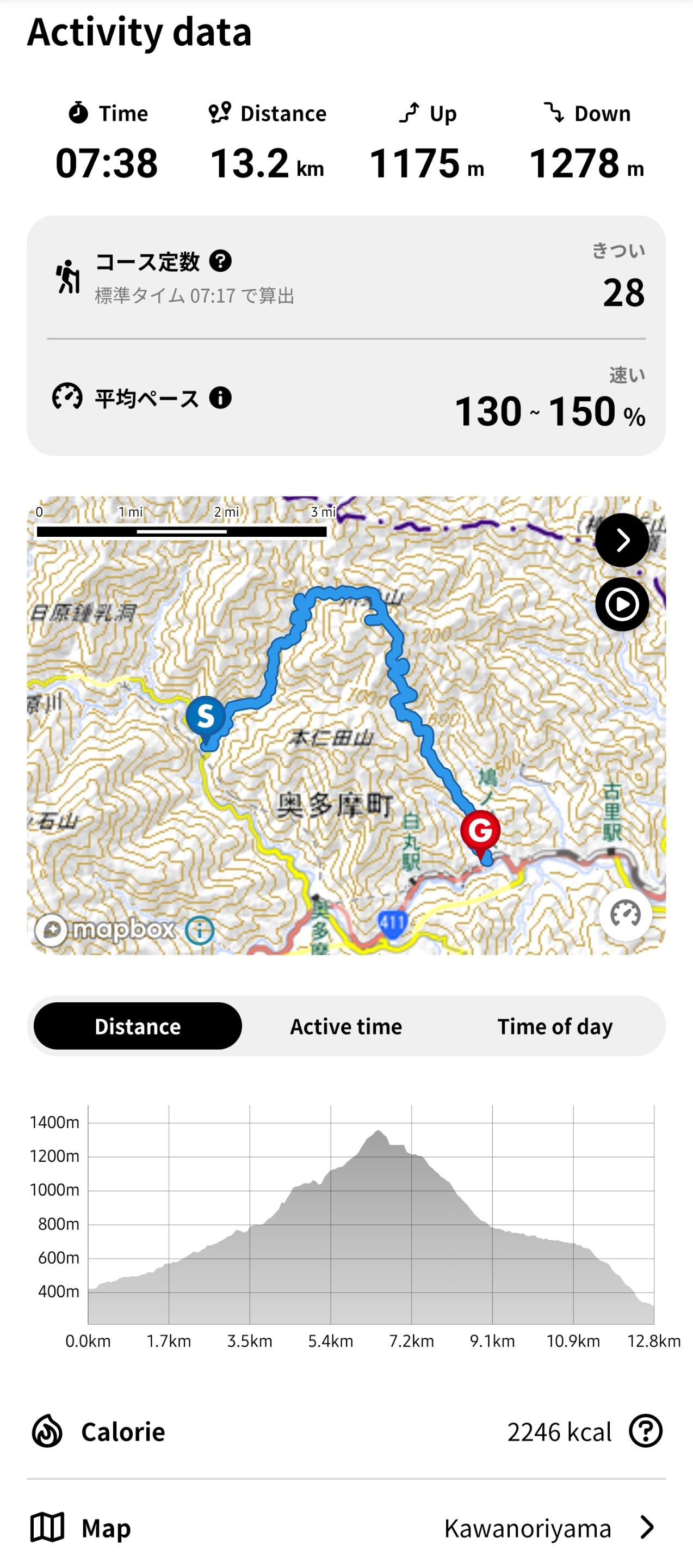
that trail had a difficulty of 28 based on our mountain climbing app, and we have been climbing for 7 and a half hours.
this is one i would never forget.
as always, stay safe!
AMPING KANUNAY!
i guess i needed those words after that trip after all.

all content is by yours truly unless otherwise specified
all photos are taken with a galaxy s23 ultra
This report was published via Actifit app (Android | iOS). Check out the original version here on actifit.io 
 10/08/2024
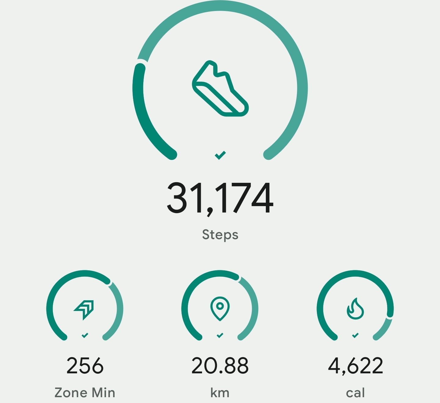
  31174
31174  Hiking
  Height 168.0 cm
  Weight 72.4 kg
  Body Fat 19.5 %
  Waist cm
  Thighs cm
  Chest cm


Powered By HIVE 
Price Data provided By CoinGecko
© Copyright Actifit 2025 | 1.6.6 |
Privacy Policy |
Terms & Conditions